Part 2: From the Bothy at Srahmore to Ballycastle
The trip is 54 kilometres long with 620 metres of climb.
The climbing is well spaced with a long descent to Ballycastle and sea level at the end. It took me 7 hours at roughly 8 kph. I stopped on many occasions to talk to people especially in the Sheskin section and I also stopped to eat and admire the scenery.
I started out at 10.00 on a fine day in May.
The route starts at the bothy where there is car parking and picnic tables and it is also possible to overnight in the bothy, it has a hard floor, and be sure to close the door securely when leaving, to keep the sheep out!
You can watch out for the black marker posts with the yellow man, they point the Western Way for hikers. At times you might be going too fast to notice them, so take care to have your gpx route live.
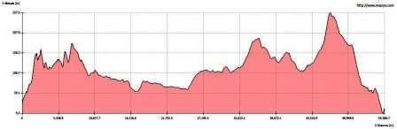
A profile of the route somewhat distorted
The first 4 kilometres or so will take you along the Altacooney River crossing it by bridge after a kilometre. Just beyond the bridge the river broadens out and the area is popular for camping with green and flat floodplains, and they are floodplains so remember that the water could rise if there was sufficient rain.
Already you are out of phone coverage, though it will return intermittently during your ride, especially on the road sections. Connection with society is gone so enjoy the quiet, the sound of wind in the trees and your own bike sounds. Passed the first barrier, no problem getting through any of the barriers, and you are in the shadow of Coirin to your left. This mountain seems higher than it is because of the steep slopes, though at its highest it is only 286 metres. On the far side of it are the caves of Coirin, local stories abound, smugglers, gold etc. What we do know is that during the war of independence men from the West Mayo Flying Column hid out here, probably in those same caves. Sheep Gap is the name given to the low pass [signposted for walkers] that takes you across the Letterkeen Loop and back to the bothy via The Bangor Trail.
Nephin Beg [627metres] looms ahead; this mountain gives its name to the whole range, despite Nephin Mountain being higher [806metres]. There is a wonderful mountain shelter ahead where one could spend a night with only the stars for company. It is not much used and remains in very good condition.
Before that it is worth noting that Ballycroy National Park, Ireland’s first wilderness area touches the trail from the west. Nephin Beg, Slieve Carr, and Corslieve the high mountains to the west and North West are all in the park. The isolation here will only be matched beyond Sheskin, later in the journey.
Here too you cross the watershed, behind you the waters drain towards Loughs Feeagh and Furnace and for now the river Deel will swing away to the east and streams that feed the Owenmore River will flow north.
It was along here that I met a stag one day as I whizzed around a bend in the forestry track, I am not sure who got the bigger fright. We stared each other for seconds before the stag with a majestic set of antlers charged away up a fire break; thankfully he did not charge me. Deer are again becoming plentiful in these mountains.
The coniferous forests do support bird life, species such as Crossbill, Coal tit, Goldcrest, Siskin and Redpoll have adapted to living in the forest. Of course there are the usual well known types such as Blackbird and Song Thrush and Robin.
The next 5 kilometres are fairly flat and I was able to make reasonable speeds. By 11.30 I was exiting the forest at Derry. It was at a shooting lodge near the exit that valuable archives were stored during world war two.
4 kilometres to the main road the R312 to Bellacorick, 17 kilometres under the belt and 4 to Bellacorick. This might be why I chose slick tyres over knobbly ones. I had no problems with tyres throughout my journey, it is worth saying. Bellacorick is where the old peat burning power station once stood. It was originally commissioned in the 1950’s I believe. The cooling tower was demolished in 2010. I was doing 23 kph as I passed the old station. Just remember this is the N59 for 4 kilometres or so. The new wind turbines turn slowly in the distance, these ones are not controversial, no houses in close proximity. Watch out for the musical bridge as you cross the Owenmore. You can play musical notes by running a stone along the parapet. It works; I tried it many years ago.
Just back the N59 2 kilometre towards Crossmolina is Lough Dahybaun. This fellow blends history and folklore. According to Willie Nolan from Eskeragh he was Fearadach, king of Connacht and of Ireland in 406 AD his death is recorded in 427 AD. The folklore says he died in the Alps, but there is a Slieve Alp to the west near Ballycroy so that may be the place, another story says he was a highwayman who terrorised the area, was eventually caught and drowned in the lake which now bears his name. There is more but right now I continue on mulling over these wonderful stories.
Watch out for the church at Ballymonnelly, the next turn is to the right after that. Now for the next section of the trip, 30kilometres of isolation and one escape route equally isolated. This is my favourite part of the trip, perhaps even my favourite part of Mayo.
I am now on a spiritual high as I head up the track. Away to my right the now abandoned peat bogs that once supplied the power station lie under a developing blanket of green mosses and sallow or willow bushes encroach. Once I passed here with some students on a hike and we had the experience of seeing a bog fire, a man from the power station told us that the fire was burning underground and that to cross the bog could be terminal as you would not know where exactly the fire was at any one time. Yet the surface looked calm just as the sea can hide a predator so to the bog can hide a variety of threats.
Sheskin lodge was a beautiful ruin when I first passed this way sometime in the early 1990’s it is now in new ownership and it is a sad plundered place, large machines threshing about have done little to enhance the once magnificent lodge. Perhaps one day it will return to former magnificence. Sheskin is the largest townland in Ireland 6997 acres [2915 hectares] Seisceann means a sedgy mountain. There were never more than 100 people living in the townland, nobody lives here today. The lodge was originally owned by the MacDonnell family, one of whom fought with the French in 1798. The Jameson family, of whiskey fame also owned it and rebuilt it. TH White who wrote The Once and Future King rented the lodge during the Second World War; he was a pacifist while here he wrote “The Godstone and the Blackymor” another intriguing story.
You are now cycling on forestry roads and pass a few ruined farm buildings once part of the Sheskin estate. At 32kms the road ends and a new adventure begins cycling on boards these blanks were place here by the Coillte the Forestry Commission. Two six inch boards two inches deep running parallel with a slight gap in the middle, just enough to facilitate mountain bike tyres or my slicks. I enjoy this section whizzing along like a train on tracks, monorail to be precise. There is about 4 kilometres of this but there are steps built into the track so you need to be careful. I came off a few times while trying to be clever. At 31.6 kilometres you meet with a very ruined house, a hut really, Professor Seamus Caulfield of Céide fields told me the name of the people who lived there into the twentieth century, but I have forgotten.
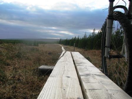
The 4 kilometer board walk your tyre fits the groove
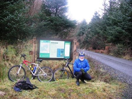
The entrance to Sheskin forest
It was 14.44 when I crossed this watershed, 6 kilometres to go to Altderg, the one point where you can leave the Western Way, but to what avail, the distance out to a road is just as far as the journey on to Ballycastle. At Altderg I had completed 42 kilometres and had almost 5 kilometres of climbing ahead possibly the hardest part of the trip. What keeps you going is the knowledge that the last 7 or 8 kilometres is downhill.
Somehow the place names here remind me of Lord of the Rings, Anierin for instance. Keerglen to the east of Altderg is where Queen Maeve’s daughter, Cainer, was killed.
At 260 metres on the 46th kilometre you pass the highest point of this part of the trip. All downhill through Glencullin to Sralagagh. Céide Fields that splendid Neolithic interpretative centre of these major Stone Age farms is only 5 kilometres to the North West. In fact there are megalithic tombs everywhere in the landscape, I will refer to a very special one that is accessible in part 3 of this trip. For the moment enjoy the fact that you are in the presence of our ancient Irish ancestors.
Turn right when you cross Ballyglass Bridge and there is a parking spot with a picnic table. This is where I finished this section of the Western Way, 54 kilometres later at 17.00 hours some 7 hours after I started, at an average speed of 8 kms though this figure is misleading as it is an overall average not a moving average.
Have to say that this is my favourite part of the western way whether to hike or bike. It is for me something of a spiritual experience.
The next part of the trip will be on my road bike offering new and different insights on The Western Way.