Part 3: From Ballycastle to the Sligo border by road bike.
I chose my road bike for this section of the trail because it follows quiet country roads and only at the end does it use walking or mountain bike surfaces. I started where I left off the last day, at the picnic spot just north of the town of Ballycastle. There is a nice cafe nearby that serves coffee and light lunches etc. I recommend it. The town itself is small, there only one street, but it has a bright open air to it, a sense of sincerity.
The Western Way turns north to Bunatrahir Bay almost immediately, and after less than 2 kilometres you reach the shore, the road is often sand covered, blown there by the onshore winds. There is a nice beach here worth a visit, perhaps it was here that the first farmers who tilled the fields at Céide came ashore. I imagine their currach like boats beached along the shore while the newcomers scanned the forested hills beyond. The freshwater stream from Ballinglen mumbling its way to the sea would have delighted them.
Lots of ring forts in the area testify to the presence of later Gaelic farmers, our own direct ancestors for the most part. Though the blood of those Neolithic farmers must surely still run in the veins of many a local. The roads are narrow here with only a few tractors inching their way from farm yard to field. Cattle and sheep are more numerous than people. The western Way passes the old ruined church at Ballintemple, a remnant of an early Christian community. An easy climb and a left at a T junction leads east across the hill to Lecarrowtemple and a long downhill to Glebe.
Two kilometres to the north of the way, at the edge of a forest is one of the finest court tombs in Mayo if not in Ireland. I call it Sceir tomb and it was excavated in the early years of this millennium. There are three chambers and a lovely neat court. Nearby the archaeologists found the site of a house and there are also field walls attached to a corner of the court. Its isolation creates a sense of the mystical, the presence of the long ago, of figures moving through an ancient landscape.
The reverie passes and I move on. I continue spinning down toward Castlelacken Demesne. This was one of the Palmer’s estates here in Mayo, they had associations with Rush in county Dublin where some of my ancestors originated, but there we were merely their tenants. At one stage they had over 80,000 acres; they had arrived here in 1681, during that troubled century.
Any way you can see the ruin of Castlelacken as you cycle downhill. Just around the corner watch out for the memorial to the first French soldier who fell here in 1798, for it was just across the salt marsh at kilcummin that the French landed in August 1798. Geographers call the low area a lacustrine delta, there must have been lakes here at some stage.
There is another tradition about the area:
“Tradition maintains that in ancient times Foghill formed part of ‘Silva Focluti’ the celebrated Wood of Focluth which once encompassed the area from Lacken Bay to Rathfran and onwards to Crosspatrick”
The connection is that St. Patrick mentions this place in his writings the only place he mentions. The Wood of Focluth where in a dream he heard those who were there calling to him. Now that is interesting why would he mention this place if he did not know it. This conflicts with the Slemish theory as his place of slavery. Perhaps he experienced both.
The Neolithic people have left many remains in the area, but it is a Bronze Age wedge tomb that is nearest the road as you pass along. It is somewhat damaged as a stone circle was bulldozed into the back of it in a time when its significance was not recognized [well that’s the best excuse I can offer for the culprit who did the damage].

?
The landscape here is remarkable, apart from the wedge tomb there are ring forts a Dominican friary at Rathfran and in the distance Killala round tower, not to mention the ruin of an 18th century landlords house, Summerhill house home of another Palmer family, though it was a John Bourke who resided there when the French invaded in 1798.
Yet we cannot tarry but hurry on to cross Palmerstown Bridge, count the arches yourself. Here the first skirmish was fought between Fraser’s Fencibles and the French as they marched towards Killala.
Apparently St. Muredach was the first bishop placed here by Patrick, though the place was named for the Cell of Alaid, corrupting to Killala in later times. The round tower is one of five in Mayo. There are roughly 65 on the whole island of Ireland. Yeats and Lady Gregory set the play Cathleen Ní Hoolihan written in 1902 in a cottage near Killala, Yeats himself stayed in the big house near the community centre, named? By the way when you reach Killala you have completed 22 kilometres.
We are now heading for Boher Na Sop a small road that follows the coast and brings us all the way to Beleek Woods and Ballina. Along the way are Moyne Friary and Rosserk Friary. Both of these were Franciscan foundations, the latter a Third Order friary of brothers. Rosserk is in splendid condition and worth the short detour especially if you are on a bike, as it is one of the best preserved Franciscan Friaries in Ireland.
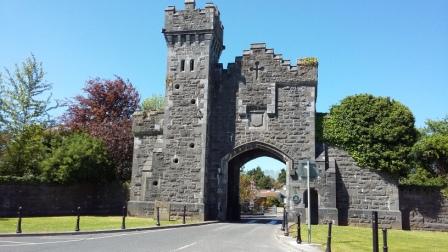
I just love Beleek woods. The trail winds along the river Moy, one of Ireland’s most famous salmon fishing rivers. If you have time visit Beleek castle dating from the 1800s, this grand, neo-gothic manor, is a gem. It was built by the Knox family in 1831 for £10,000 on the site of a former abbey, one of four along the Moy. Today most of the grounds are a public amenity and as you exit the castle grounds you pass a magnificent gate house with an arch, stop and admire.
?
Ballina is a wonderful town it has accommodation and food for those who wish to stay over. During the fishing season, which I confess to know little about, you can watch the anglers fish the famous ridge pool. this is Ireland’s most famous salmon fishing spot where the freshwater of the Moy meets the salt water of the long estuary that reaches all the way to Killala.
After you cross the bridge, watch for the sharp right turn that takes you along the bustling Brusna River and into the quiet countryside. The landscape is changing here, gone for the moment are the wild bogs of north Mayo, and the leafy woods of Beleek. Now we are in a country of small field’s cattle and some sheep graze among those fields. Small farms dot the landscape.
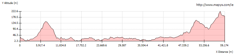
Just after Behy national school, which is on your left, the ground begins to rise imperceptibly, there will be more downhill’s but overall you will gain an easy 150 metres. As you cross the R294 you have completed 45 kilometres or so. 15 or so kilometres to go. You can tell by the deterioration of the land quality, bog and forestry will be your companions for the rest of the way. The excellent views will compensate for the deterioration of the trail. The trail will swing sharp left and a pretty level ride for a while until you are less than a kilometre east of Bunnyconnellen a small town on the R294. 6 kms to go I was tired at this stage and got a puncture to add to that. There is a car park where you cross the R294 again, you could walk the rest of the way to the border 2 kms away and walk back to your bike. [Lock it, even here, opportunity thieves do exist, sadly] the surface is not suitable for a road bike. You can also see the beginning of the Ox mountain trail. I was involved with putting that trail in place many years ago. It too is a great hike, though heathery in places.
So you have reached the Mayo Sligo border, you can now, if you wish, continue on to the Sligo way. you have completed just over 59 kilometres.
Well that’s it in three blogs. I have described my journey from Newport county Mayo to the Sligo border by bicycle using as the terrain demanded a mountain bike and a road bike.
It was exhilarating, demanding at times, the sense of aloneness was enervating. I just love that feeling of being cocooned in one’s own world, moving along, observing, feeling at one with machine and earth, self propelled. At times the only sound was the wind in the trees and the birds in the air.